Yahoo News
 Storm Kathleen - live: Over 100 flood alerts in place as heavy gusts and rain leave thousands without power
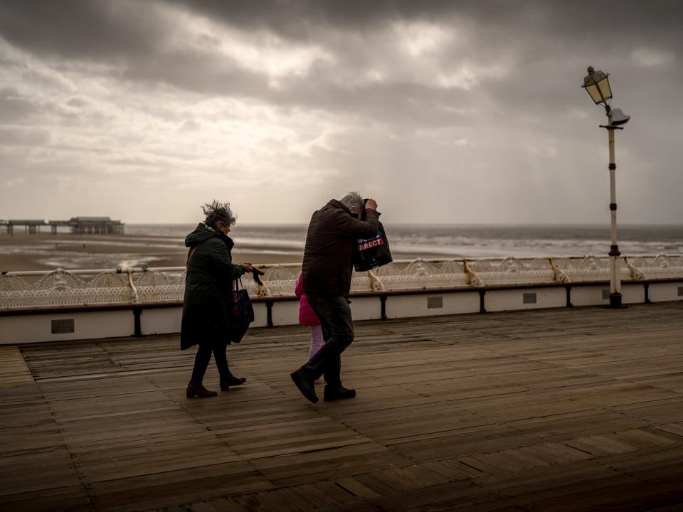
Thousands of homes remain without power as Storm Kathleen continues to tear across the country with heavy rain and winds of up to 70mph.
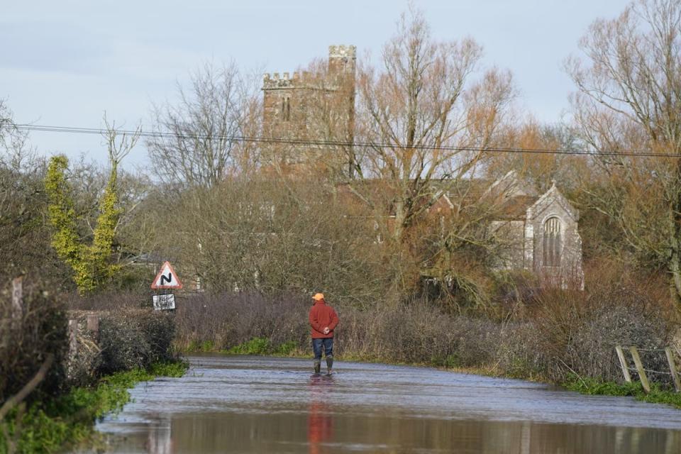
The Environment Agency has issued 119 flood alerts and 19 flood warning across England and Wales as further rain is expected to fall overnight in parts of Wales and the south west of England this evening.
Around 12,000 customers remained without electricity in Ireland on Saturday evening after Storm Kathleen swept across the island, with many remaining without access to electricity overnight.
A spokesman for ESB Networks said: “ESB Networks crews will continue to work late into the evening with a view to restoring supply to the vast majority of impacted customers by tonight.
“However, there will be some customers without power overnight.”
Strong winds are expected to persist tomorrow with a further yellow warning for wind has been issued for north-west Scotland on Sunday between 9am and 3pm.
The high winds also caused travel disruption, about 70 flights departing and arriving at UK airports before midday on Saturday were cancelled
Despite stormy weather, Saturday has provisionally become the hottest day of the year so far with 20.9C recorded, the Met Office said.
Key Points
Power cuts for thousands as Storm Kathleen sweeps across Ireland
Gusty winds and blustery showers in store for Saturday- but east to look forward to sunshine
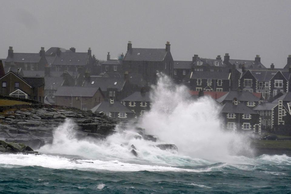
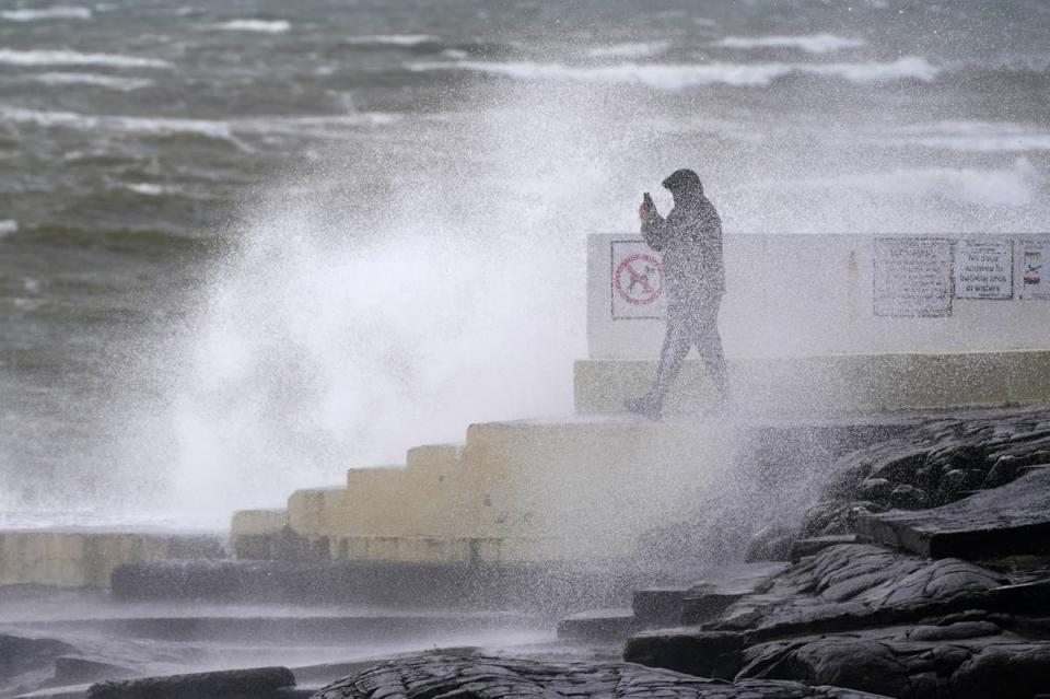
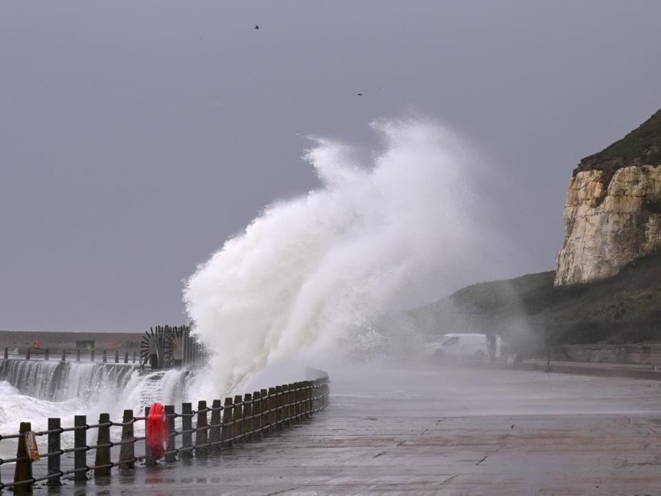
Huge waves expected as gusts of 70mph set to batter west coast
Strong wind and rain set to hit the UK this weekend, the Met Office said.
Storm Kathleen map: Which parts of the UK will be hit by heavy winds?
07:15 , Lydia Patrick
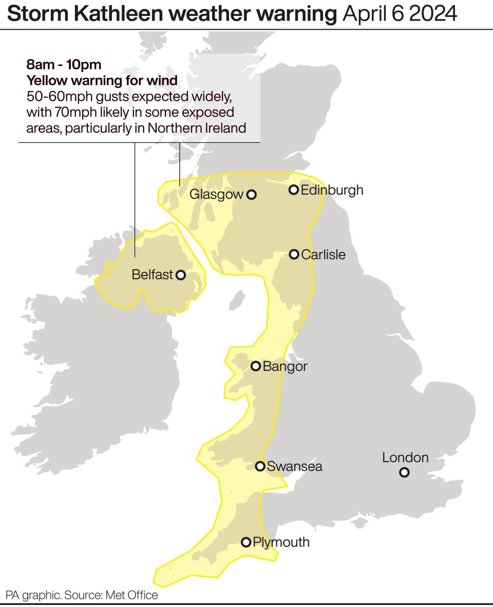
The Met Office has issued a danger to life yellow weather warning as Storm Kathleen barrels into the UK and Ireland with 70mph winds.
The storm, the 11th of the season and named by the Irish Meteorological Service on Thursday, rolled in with blustery conditions on Friday.
Gusts of up to 60mph to 70mph in exposed areas are expected along western areas of the UK, including the northwest and southwest of England, Northern Ireland and parts of Scotland and Wales.
Read the full story here...

Mapped: Which parts of UK will be battered by Storm Kathleen?
When will the stormy weather subside?
06:15 , Lydia Patrick
Storm Kathleen will ease on Sunday evening, but another weather system towards the South West will replace it, Ms Glaisyer added.
She said: “Outbreaks of rain through Monday will mainly affect western parts of the UK. As we go through the day into Tuesday we’re likely to see the strongest wind across the south-west of the UK.
“It’s coming relatively quickly after Storm Kathleen.
“It’s not out of the question that a warning could be issued but I wouldn’t like to say yet.”
RAC’s advice to drivers
05:15 , Lydia Patrick
RAC Breakdown spokesman Rod Dennis said: “This intense period of stormy weather is going to prove extremely challenging for anyone driving on the western side of the UK.
“We strongly urge drivers to avoid exposed coasts and higher routes where the impact of the very strong winds is most likely to be felt.”
Watch - Storm Kathleen prompts cancellation of dozens of flights
04:15 , Lydia Patrick
Flood alerts and wind warnings issued as Scotland battles Storm Kathleen
03:15 , Lydia Patrick
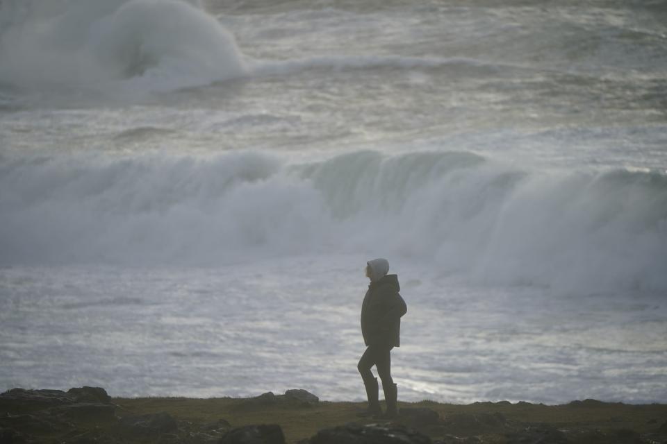
Scotland is battling a weekend of heavy rain and high winds, with a number of flood alerts and wind warnings issued as Storm Kathleen continues.
The Scottish Environment Protection Agency (Sepa) has 18 regional flood alerts and 43 flood warnings in place in Scotland, an increase from 16 alerts and 34 warnings earlier on Saturday.
Vincent Fitzsimons, Sepa’s flood duty manager, said: “Across the weekend, Scotland is braced for impacts from Storm Kathleen including very high winds and coastal flooding in western areas.
“Flooding impacts are expected across western coastal areas throughout the weekend.
“Impacts start in the Solway coast and Firth of Clyde on Saturday and then move around the coast to the eastern side of the country over the next few days.
“Of particular concern is the likely impact to communities in the Western Isles and Orkney late Saturday and across Sunday.
“On top of already high tides, Kathleen will bring a storm surge and large waves. This combination is particularly dangerous – especially around high tides.
“There is real danger to life from wave overtopping, particularly around causeways, coastal roads and paths.
“Disruption to travel and infrastructure is possible, as is isolated flooding to coastal properties and communities.
“While the risk is greatest around high tide times, our message is clear: take extra care if you are near the coast at any point and stay well clear of waves and water.
“Be careful when travelling around exposed coastal areas and don’t walk or drive through flood water as there may be hidden hazards.”
Mapped - Flood alerts and warnings across the UK
02:15 , Lydia Patrick
There are 19 warnings and 119 flood alerts in place across the country as more heavy rain is set to arrive this evening.
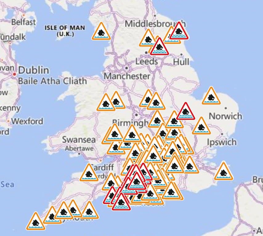
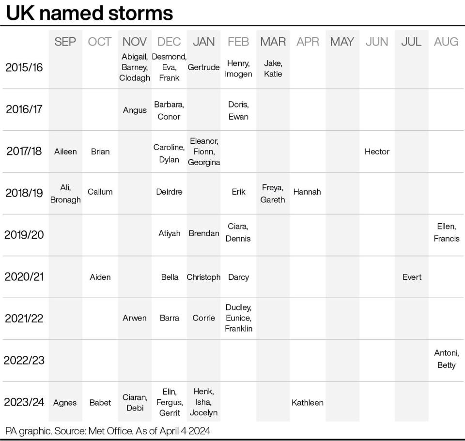
Chart to show UK’s named storms
01:15 , Lydia Patrick
12,000 remain without power as Storm Kathleen brings disruption across Ireland
Sunday 7 April 2024 00:15 , Lydia Patrick
Around 12,000 customers remained without electricity in Ireland on Saturday evening after Storm Kathleen swept across the island.
The number had fallen from a peak of around 34,000 outages earlier in the day.
The high winds also caused travel disruption, with some flights to and from Dublin and Belfast City airports cancelled.
An orange wind warning for Cork, Kerry and Waterford that came into effect at 7am lifted at 2pm, while another status orange wind warning for Galway and Mayo lapsed at 6pm.
A yellow wind warning was in effect across the rest of Ireland until 8pm.
The yellow warning will remain in place for Donegal, Mayo and west Galway until 4pm on Sunday.
The remaining outages on Saturday evening were concentrated in Mayo, Sligo, Leitrim, Laois and Wicklow.
A spokesman for ESB Networks said: “ESB Networks crews will continue to work late into the evening with a view to restoring supply to the vast majority of impacted customers by tonight.
“However, there will be some customers without power overnight.”
Storm Kathleen wreaks havoc as flights grounded and thousands without power in 70mph winds
Saturday 6 April 2024 23:15 , Lydia Patrick
Dozens of UK flights were cancelled as Storm Kathleen brought winds of up to 70mph and left 34,000 people without power.
Strong winds have battered the UK as two yellow warnings have been issued for the whole of Northern Ireland and the west coast of England, Wales and southern Scotland from 8am this morning to 10pm tonight.
A second weather warning will encompass northwest Scotland from 9am to 3pm tomorrow across Eilean Siar, Highland and Argyll, and Bute.
As downpours and gusts persist overnight, Sunday should be drier for most with sunshine expected and warm temperatures in the south, according to the Met Office.
Read the full story here...
Storm Kathleen wreaks havoc as flights grounded and thousands without power
Watch - Plane aborts landing as Storm Kathleen grounds more than 100 flights
Saturday 6 April 2024 22:15 , Lydia Patrick
Saturday 6 April 2024 21:15 , Lydia Patrick
Mapped: Which parts of UK will be battered by Storm Kathleen
Saturday 6 April 2024 20:15 , Lydia Patrick
The Met Office has issued a danger to life yellow weather warning as Storm Kathleen barrels into the UK and Ireland with 70mph winds.
The storm, the 11th of the season and named by the Irish Meteorological Service on Thursday, rolled in with blustery conditions on Friday.
Gusts of up to 60mph to 70mph in exposed areas are expected along western areas of the UK, including the northwest and southwest of England, Northern Ireland and parts of Scotland and Wales.
Read the full story here...
Mapped: Which parts of UK will be battered by Storm Kathleen?
Heavy rain this evening, says Met Office
Saturday 6 April 2024 19:14 , Lydia Patrick
As well as strong winds, heavy downpours are set to hit parts of Wales and the south west of England this evening, the Met Office warns.
Meteorologists have advised drivers to take extra precaution due to a risk of hazards from localised flooding.
🌧️ As well as strong winds, #StormKathleen is bringing heavy rain to parts of Wales and southwest England this evening
🚗 Take care if you are travelling as there could be localised flooding and disruption pic.twitter.com/TVWG2kPngQ— Met Office (@metoffice) April 6, 2024
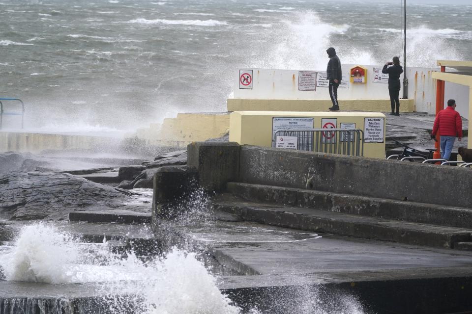
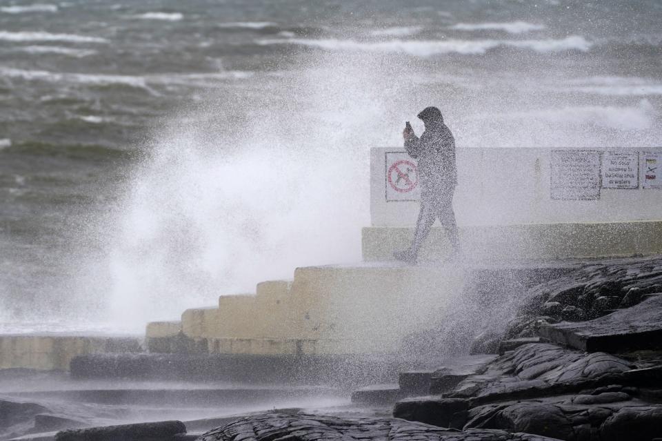
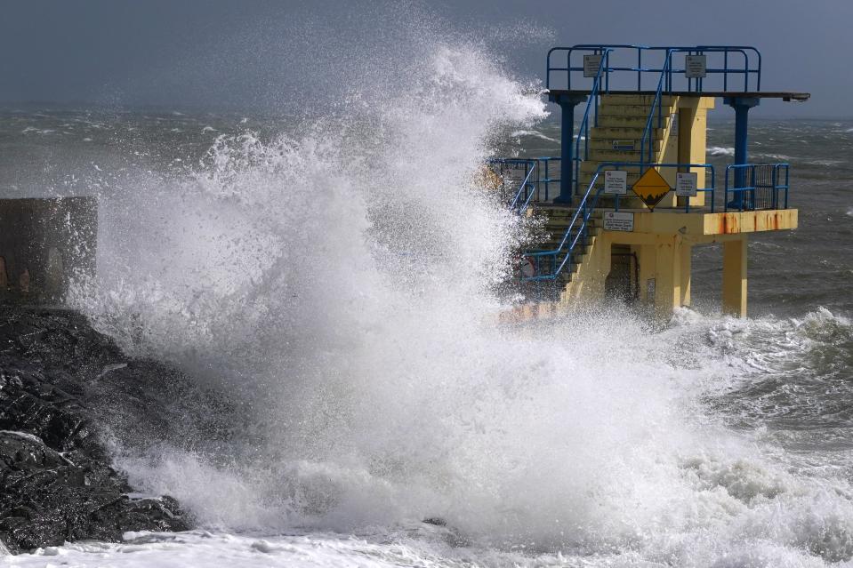
In Pictures- Storm Kathleen hits the UK’s coastlines
Saturday 6 April 2024 18:14 , Lydia Patrick
#StormKathleen #Storm Salthill. 1 hour before high tide. pic.twitter.com/SqWSgqfCsT
— Galway Atlantaquaria (@GalwayAquarium) April 6, 2024
The Sand being churned up by Storm Kathleen in Strandhill this afternoon @CarlowWeather #StormKathleen #lovesligo #Strandhill pic.twitter.com/o2CzzZjOPL
— James Burke (@jamesburke01) April 6, 2024
While we're well used to high seas and surf around Mullaghmore head, the harbour is always eerily calm.
NOT today. #StormKathleen #sligo pic.twitter.com/y4tGGv0gTe— Gerry O'Donnell (@gerryodonnell0) April 6, 2024
Tomorrow’s weather forecast
Saturday 6 April 2024 17:27 , Lydia Patrick
As strong downpours and gusts persist overnight, tomorrow should be drier for most with sunshine expected and warm temperatures in the south, according to the Met Office.
In the north west, temperatures will be closer to average and it will remain windy, particularly across the north west of Scotland.
Today hottest day of the year so far, Met Office says
Saturday 6 April 2024 16:34 , Maryam Zakir-Hussain
Saturday has provisionally become the hottest day of the year so far with 20.9C recorded, the Met Office said.
The highest temperature was reached in Santon Downham, Suffolk, on Saturday afternoon.
Risk of fallen trees and flooding in Ireland as strong winds whip up
Saturday 6 April 2024 16:13 , Maryam Zakir-Hussain
Forecaster Met Eireann had warned of gale force southerly winds bringing a risk of difficult travel conditions, fallen trees, power outages and flooding along coastal areas.
Keith Leonard, national director of the National Directorate for Fire and Emergency Management (NDFEM), urged people to stay away from all coastal areas during the Met Eireann warnings.
“Importantly, I would remind people that it is critical that they never ever touch or approach fallen wires,” he said, urging people to contact ESB Networks instead.
34,000 without power as Storm Kathleen brings disruption across Ireland
Saturday 6 April 2024 15:12 , Maryam Zakir-Hussain
Around 34,000 customers have been left without electricity as Storm Kathleen continues to sweep across the island of Ireland.
The high winds also caused travel disruption, with some flights to and from Dublin and Belfast City airports cancelled.
Power outages reported on Saturday were concentrated in Mayo, Galway, Kerry and Cork.
A spokesman for ESB Networks said: “Crews are mobilised in impacted areas and responding to power outages where safe to do so.
“ESB Networks is continuing to monitor the situation as Storm Kathleen tracks across the country and weather warnings remain in place.
“With high winds forecasted into the afternoon, further outages can be expected in impacted areas.”
Storm Kathleen forces Edinburgh to move Bayonne match to Murrayfield
Saturday 6 April 2024 14:00 , Maryam Zakir-Hussain
Edinburgh have moved their European Challenge Cup tie against Bayonne on Saturday evening to Murrayfield due to Storm Kathleen.
The round-of-16 tie was to be played at the Hive Stadium next door to Murrayfield, but the venue has been switched because of the strong winds which are set to hit Edinburgh on Saturday.
Edinburgh said their operations team and Scottish Rugby health and safety officials had been in contact with the Met Office to discuss the impact of the yellow warning for the wind. The game’s 8pm kick-off time remains unchanged.

Storm Kathleen forces Edinburgh to move Bayonne match to Murrayfield
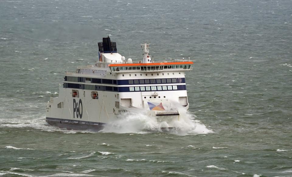
P&O Ferries cancels sailings between Larne in Northern Ireland and Cairnryan in Scotland
Saturday 6 April 2024 13:18 , Maryam Zakir-Hussain
P&O Ferries has cancelled the sailings between Larne in Northern Ireland and Cairnryan in Scotland until 4pm on Saturday due to the storm.
Meanwhile Saturday evening’s EPCR Challenge Cup rugby match between Edinburgh Rugby and Aviron Bayonnais has been moved to Scottish Gas Murrayfield from Hive Stadium due to the strong winds expected.
Ms Glaisyer added: “Almost anywhere is going to see above-average temperatures. Western parts of the UK are likely to see temperatures of 15 or 16C.
“However, the further west you are, where those strongest winds are in that yellow warning area, despite the temperatures being above average it will feel a little colder.”
Power cuts for thousands as Storm Kathleen sweeps across Ireland
Saturday 6 April 2024 11:48 , Maryam Zakir-Hussain
Thousands of customers have been left without electricity as Storm Kathleen sweeps across the island of Ireland.
An orange wind warning for Cork, Kerry and Waterford came into effect at 7am and will lift at 2pm, while another status orange wind warning is in place for Galway and Mayo until 6pm.
A yellow wind warning is in place nationwide until 8pm.
Power outages reported on Saturday morning were concentrated in the south and west of the country.
Forecaster Met Eireann has warned of gale force southerly winds bringing a risk of difficult travel conditions, fallen trees, power outages and flooding along coastal areas.
Southerly winds bringing warmer temperatures today
Saturday 6 April 2024 11:45 , Maryam Zakir-Hussain
Met Office meteorologist Ellie Glaisyer said: “The storm is the reason we are seeing the warmer temperatures, because the location of the storm – situated out towards the west of the UK – is bringing a southerly wind across the UK.
“This is bringing those warmer temperatures from the continent, meaning we are likely to see temperatures reaching 22C.”
The highest temperature of the year so far was 19.9C, recorded at the end of January at Achfary in north-west Scotland.
Dozens of flights cancelled as Storm Kathleen hits UK
Saturday 6 April 2024 10:55 , Maryam Zakir-Hussain
Dozens of UK flights have been cancelled as Storm Kathleen brings winds of up to 70mph – and potentially the hottest day of the year so far.
About 70 flights departing and arriving at UK airports before midday on Saturday have already been cancelled as the Met Office issued a yellow weather warning for wind.
A further yellow warning for wind has been issued for north-west Scotland on Sunday between 9am and 3pm.
Trains across Scotland to run slower
Saturday 6 April 2024 10:07 , Simon Calder
Network Rail Scotland says: “Storm Kathleen will bring 50-60mph winds to Scotland from around lunchtime today. Based on that, we’ve taken the decision to slow trains down in several areas between 12 noon and 7pm.
“On the West Highland Line, trains will run slower than normal along most of the route – including the Oban and Mallaig branches. On the Borders Railway, trains will run slower than normal along the entire route.
“On the Glasgow Central – Edinburgh Waverley routes, we’ll also slow trains down. For services running via Carstairs it’ll be for around 6 miles near Auchengray. For services running via Shotts, it’ll be for around 8 miles between Shotts and Addiewell.
“Our specialist weather forecaster, based in our control room, will monitor the storm using live wind data. If we can remove these speed restrictions sooner, we will. Likewise, if we need to take further action, we will. If that happens, we’ll let you know though.
“If you’re travelling one of the routes we’ve mentioned today, your journey will take longer than usual, so please do check your journey before you leave the house. We’ll update you again following our next extreme weather meeting at lunchtime.”
Mapped: Which parts of UK will be battered by Storm Kathleen
Saturday 6 April 2024 09:28 , Maryam Zakir-Hussain
The Met Office has issued a danger to life yellow weather warning as Storm Kathleen barrels into the UK and Ireland with 70mph winds.
The storm, the 11th of the season and named by the Irish Meteorological Service on Thursday, rolled in with blustery conditions on Friday.
Gusts of up to 60mph to 70mph in exposed areas are expected along western areas of the UK, including the northwest and southwest of England, Northern Ireland and parts of Scotland and Wales.
Mapped: Which parts of UK will be battered by Storm Kathleen?
UK set to have hottest day of year so far – as Storm Kathleen tears towards Britain with danger-to-life winds
Saturday 6 April 2024 08:49 , Maryam Zakir-Hussain
The UK is expected to record its hottest day of the year so far – as storms batter parts of the country with heavy rain and winds that pose a risk to life.
The Met Office said temperatures on Saturday could reach up to 22C in East Anglia, but issued a yellow warning elsewhere for gusts of up to 70mph.
Road, rail, air and ferry travel could all be disrupted as Storm Kathleen rolls in, forecasters said.

UK set to have hottest day of year so far – as Storm Kathleen winds threaten life
Mercury could hit 21C
Saturday 6 April 2024 07:00 , Jane Dalton
Temperatures could rise as high as 21C on Saturday in Norfolk, the Met Office predicts.
⚠️ The weekend is fast approaching and so too is #StormKathleen
🌤️ But despite the strong winds, there'll also be some warm sunshine at times on #Saturday
Find out when you'll have the driest conditions by checking the #4cast 👇 pic.twitter.com/xMgYGDQH8E— Met Office (@metoffice) April 5, 2024
Storm Kathleen is coming and Lilian won’t be far behind
Saturday 6 April 2024 05:30 , Jane Dalton
No storm season has ever got beyond the letter K. But this is the second time in a UK storm season that the letter K has been reached in the alphabet:
Storm Kathleen is coming and Lilian won’t be far behind
February was wettest in 258 years
Saturday 6 April 2024 03:55 , Jane Dalton
The weekend storm comes after the Met Office’s preliminary figures showed February was the wettest in over two-and-a-half centuries:
Maps reveal where rain will hit as February poised to be wettest in 258 years
Storm to pass over Ireland and west of England
Saturday 6 April 2024 01:55 , Jane Dalton
Met Office imagery shows Storm Kathleen off the west coast of Spain heading towards the British Isles and passing over the island of Ireland and western England before pushing away towards Greenland.
👀 All eyes are on #StormKathleen which already looks impressive on satellite imagery
⚠️ This rapidly deepening storm is moving north towards Ireland but very strong winds are also expected in western parts of the UK on Saturday pic.twitter.com/bZey1dFV2g— Met Office (@metoffice) April 5, 2024
Storm to tear into UK with 70mph winds and snow
Friday 5 April 2024 23:55 , Jane Dalton
Storm Kathleen will barrel into the UK this weekend with dangerous 70mph gusts, torrential downpours and snow in some areas:
Storm Kathleen to tear into UK with 70mph winds and snow
The parts of UK that will be battered by Storm Kathleen
Friday 5 April 2024 21:55 , Jane Dalton
Mapped: Which parts of UK will be battered by Storm Kathleen?
Greenhouse gases hit new highs last year
Friday 5 April 2024 20:30 , Jane Dalton
Levels of criticial heat-trapping gases in the atmosphere reached historic highs last year, growing at near-record fast paces, according to the US National Oceanic and Atmospheric Administration.
Carbon dioxide, the most important and abundant of the greenhouse gases caused by humans, rose by the third-highest total in 65 years of record-keeping, the experts announced.
Scientists are also worried about the rapid rise in atmospheric levels of methane, a shorter-lived but more potent heat-trapping gas. Both jumped 5.5% over the past decade.
The 2.8 parts-per-million increase in carbon dioxide airborne levels from January to December was not as high as the jumps were in 2014 and 2015, but they were larger than every other year since 1959, when precise records started.
Carbon dioxide’s average level for last year was 419.3 parts per million, up 50% on pre-industrial times.
Just in: Levels of the three most important human-caused greenhouse gases (GHG)– carbon dioxide, methane & nitrous oxide – continued their steady climb during 2023. Find out how last year’s GHG concentrations measure up to previous years at the link below.https://t.co/v4xPKmTfn0 pic.twitter.com/1gQIManpDK
— NOAA Research (@NOAAResearch) April 5, 2024
Storm fast approaching
Friday 5 April 2024 19:15 , Jane Dalton
High winds will drag down effect of warm weather
Friday 5 April 2024 18:30 , Jane Dalton
The strong winds tomorrow will reduce the impact of the high temperatures, forecasters say.
“Parts of western Europe will see temperatures around 10°C above average and some of this exceptionally warm air for early April will surge northwards thanks to #StormKathleen. However, when you factor in the strong winds, it will feel several degrees colder than these temperatures suggest,” the Met Office said.
🌡️ Saturday is expected to be the warmest day of the year so far in the UK
📈 Parts of western Europe will see temperatures around 10°C above average and some of this exceptionally warm air for early April will surge northwards thanks to #StormKathleen
However when you factor… pic.twitter.com/erwXIs5rVZ— Met Office (@metoffice) April 5, 2024
UK set to have hottest day of year so far – as Storm Kathleen tears towards Britain with danger to life winds
Friday 5 April 2024 16:57 , Maryam Zakir-Hussain
The UK is expected to record its hottest day of the year so far – as storms batter parts of the country with heavy rain and winds that pose a risk to life.
The Met Office said temperatures on Saturday could reach up to 22C in East Anglia, but issued a yellow warning elsewhere for gusts of up to 70mph.
Road, rail, air and ferry travel could all be disrupted as Storm Kathleen rolls in, forecasters said.
UK set to have hottest day of year so far – as Storm Kathleen winds threaten life
Hottest day of the year so far for East Anglia on Saturday
Friday 5 April 2024 16:00 , Maryam Zakir-Hussain
Met Office spokesman Stephen Dixon said the hottest day of the year so far could arrive in East Anglia on Saturday.
He told the PA news agency: “Away from that warning area on Saturday, we could get up to 22C in isolated spots of East Anglia which would make it the hottest day of the year so far in that area.”
“One of the residual effects from Storm Kathleen is helping to draw up that warmer air as well.
“It’s not unusual for these storm systems to bring warmer air with them.”
The highest temperature of the year so far was 19.9C, recorded at the end of January at Achfary in north-west Scotland.
Mr Dixon added: “The outlook for Sunday for much of the UK is for showery conditions to continue particularly in northern and western areas again.”
“It will generally feel a touch drier the further south-east you go through the day on Sunday as Kathleen gradually moves away northwards.”
He added that the start of next week would see unsettled weather conditions with “rain continuing for many”.
UK to record hottest day of year as Storm Kathleen batters west with 70mph winds
Friday 5 April 2024 15:01 , Maryam Zakir-Hussain
The UK is expected to record its hottest day of the year so far on Saturday, as Storm Kathleen batters the west of the country with heavy rain and winds of up to 70mph.
The Met Office said temperatures could reach up to 22C in East Anglia as unseasonably warm air is drawn across parts of the UK during sunny spells.
The forecaster has issued a yellow weather warning for wind in western areas of the UK, including Northern Ireland, parts of Scotland and Wales, and the North West and South West of England from 8am to 10pm on Saturday.

UK to record hottest day of year as Storm Kathleen batters west with 70mph winds
Strong winds and high temps- what’s going on with this weekend’s weather?
Friday 5 April 2024 13:50 , Maryam Zakir-Hussain
⚠️ A windy #weekend is on the way with #StormKathleen bringing some unseasonably strong winds on Saturday, particularly in the west, but also some much higher temperatures📈
Will the weather on Sunday be any different? Find out in the weekend forecast 👇 pic.twitter.com/uNoABDyRx2— Met Office (@metoffice) April 5, 2024
Friday afternoon forecast
Friday 5 April 2024 12:50 , Maryam Zakir-Hussain
🌧️ Rain and hill snow slowly clearing northwards across Scotland this afternoon
🌦️ Sunny spells and scattered showers for much of England and Wales, with some longer spells of rain in Northern Ireland
🌬️ A windy day with temperatures above average for most pic.twitter.com/vRYpyz4als— Met Office (@metoffice) April 5, 2024
Gusty winds and blustery showers in store for Saturday- but east to look forward to sunshine
Friday 5 April 2024 12:04 , Maryam Zakir-Hussain
Met Office chief meteorologist, Dan Suri, said: “Storm Kathleen will bring strong gusty winds to western areas of the UK through Saturday. Gusts of 50 to 60 mph are expected quite widely, while some exposed spots, particularly in coastal Northern Ireland, will see 60 to 70 mph gusts with large waves also expected.
“There will also be some blustery showers in the west with the eastern side of the UK seeing a drier and brighter day. With the winds coming from the south, some unseasonably warm air will be drawn across parts of the UK.
“When combined with sunny spells in East Anglia we could see temperatures reaching 21°C or 22°C for a time on Saturday. These temperatures are well above average for the time of year and the highest we’ve seen in the UK since last October.”